
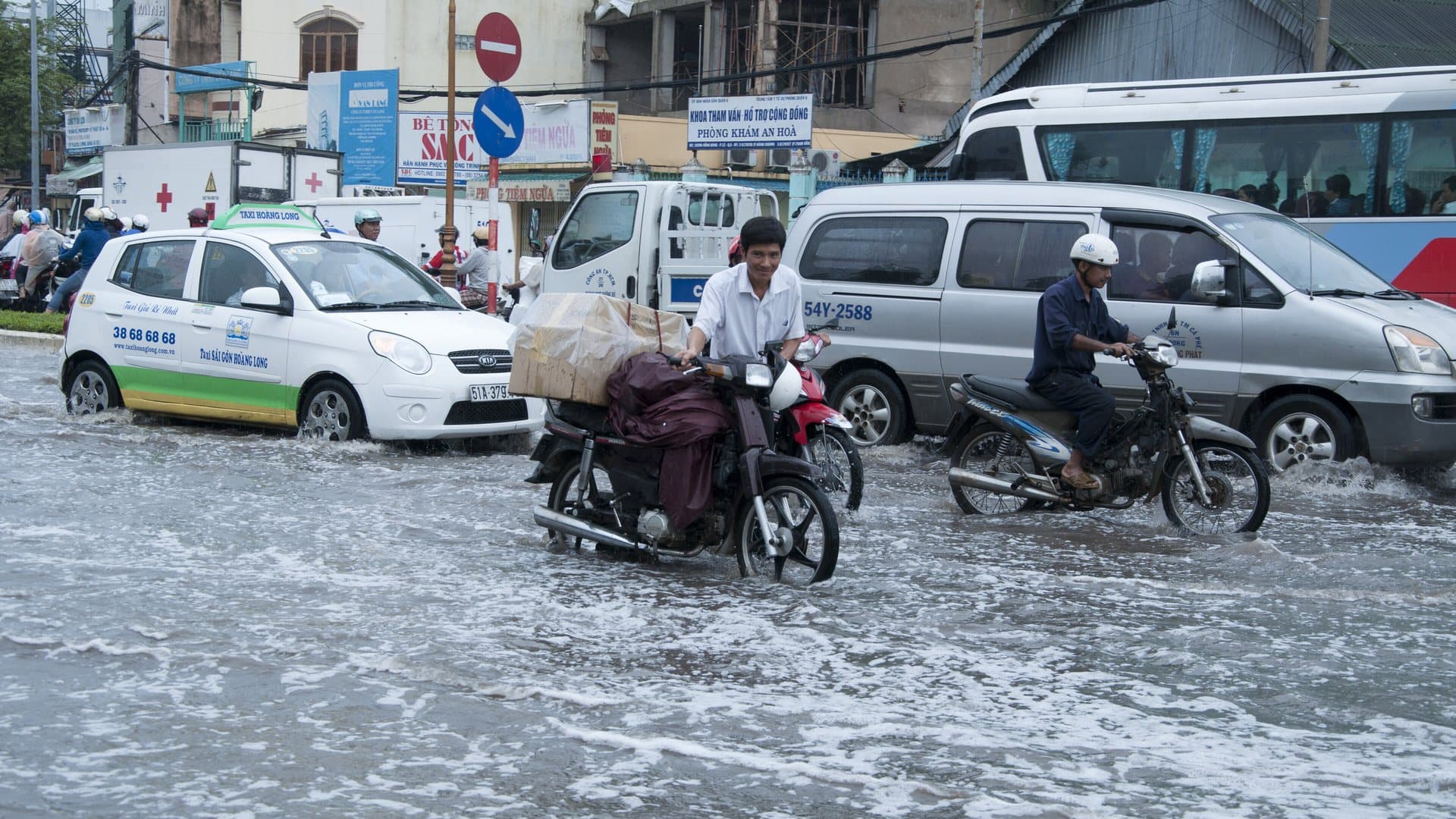
Ho Chi Minh City is hot all year (highs of 32-35°C in every month), so the season that matters is rain. December to April is the dry season, with only about 5 to 50 mm of rain a month and eight to nine hours of sun a day; April is the hottest month, at about 35°C. May to mid-November is the rainy season, bringing about 87 percent of the city's 1,930 mm a year and peaking at 325 mm in September, mostly as heavy downpours with sunny spells in between. In October and November the year's highest tides can push the Saigon River into low-lying streets, even on dry days.
That makes Ho Chi Minh City the opposite of the central coast, which is dry in summer and wettest in autumn, and closer in pattern to Cambodia next door. If you are planning a longer route, our guides to Vietnam and Cambodia together, Hanoi weather and Da Nang and Hoi An weather show how the regions line up.
Ho Chi Minh City weather at a glance
The table gives long-run monthly averages from Climates to Travel, the source behind all our month-by-month pages.
| Month | High | Low | Rain | Rain days | Sun (h/day) |
|---|---|---|---|---|---|
| January | 32°C | 22°C | 15 mm | 2 | 8 |
| February | 33°C | 23°C | 5 mm | 1 | 9 |
| March | 34°C | 24°C | 10 mm | 2 | 9 |
| April | 35°C | 26°C | 50 mm | 5 | 8 |
| May | 35°C | 25°C | 220 mm | 18 | 6 |
| June | 33°C | 25°C | 310 mm | 19 | 6 |
| July | 33°C | 24°C | 295 mm | 23 | 6 |
| August | 33°C | 24°C | 270 mm | 22 | 6 |
| September | 32°C | 24°C | 325 mm | 23 | 5 |
| October | 32°C | 24°C | 265 mm | 21 | 6 |
| November | 32°C | 23°C | 115 mm | 12 | 7 |
| December | 32°C | 22°C | 50 mm | 7 | 7 |
The year totals about 1,930 mm over 155 rain days, with roughly 2,490 hours of sunshine: far sunnier than Hanoi.
The dry season: December to April
The dry season is the easy time to visit. From December to April the city receives only about 130 mm in total (5 mm in February, 10 mm in March) and sunshine runs at seven to nine hours a day. December to February is the most comfortable stretch, with highs around 32-33°C and lows near 22-23°C. March and April are the hottest months, at 34-35°C by day and 24-26°C at night, when walking District 1 at midday is hard going.
This is also the busiest season for international visitors, and Tet (on 6 February in 2027) falls within it. Around Tet the city quietens as people travel home, many shops and restaurants close for several days, and transport out of the city fills; our Tet 2027 guide covers what to expect.
The rainy season: May to mid-November
The rains arrive in May, when the total jumps from about 50 mm in April to 220 mm over 18 days. From June to October the city receives 265-325 mm a month, peaking at about 325 mm over 23 days in September; November tails off to about 115 mm. Between May and October the city takes roughly 1,685 mm of its 1,930 mm year.
The important detail for visitors is how that rain falls. Sunshine still averages five to six hours a day through the wet months, so rain rarely takes the whole day; it tends to arrive as heavy downpours with drier spells around them. Individual storms can be intense: on 10 May 2025, VnExpress reported nearly 230 mm in 90 minutes, the city's heaviest single downpour in eight years. The practical pattern is to sightsee in the morning, keep museums and cafés for the afternoon, and carry a light poncho.
King tides: October and November flooding
Late in the year, the city's floods are driven as much by the Saigon River as by rain. The year's highest tides typically arrive in October and November, and when they coincide with heavy rain or high river levels they push water into low-lying streets, sometimes on dry days. 2025 set records: VnExpress reported that the Phu An gauge reached 1.77 m on 23-24 October, matching the September 2019 record, then an all-time high of 1.78 m at 4 a.m. on 6 November, when streets including Bui Vien walking street and Calmette Street in central Saigon went under water. The US Mission in Vietnam issued an alert that week warning of heightened flood risk along the Saigon River from the tides and Typhoon Kalmaegi's rains.
For most visitors tidal flooding is a disruption rather than a danger, and the water recedes as the tide falls. In October and November, avoid ground-floor rooms in low-lying areas, allow extra time for journeys around high tide, and watch local warnings.
Month by month
December to February is the most comfortable time: dry, sunny, and hot but not at its peak, with lows near 22°C.
March and April are the hottest months, at 34-35°C, and still dry; April sees the first storms.
May is the start of the rains, at about 220 mm, and the heat remains.
June to August is the heart of the wet season, at 270-310 mm a month, with downpours on most afternoons.
September is the wettest month, at about 325 mm over 23 days.
October stays wet, at about 265 mm, and the king-tide season begins.
November tails off to about 115 mm, with king tides early in the month; by late November the dry season is close.
What the weather means for your plans
City sightseeing. In the dry season, start early to beat the heat; in the wet season, start early to beat the rain. Our 3 days in Ho Chi Minh City itinerary and one-day plan are built around morning walking and afternoon indoor stops.
Day trips. The Cu Chi Tunnels and the Mekong Delta are both best in the dry season, when paths are dry and the heat is the only obstacle; in the wet season, go early and pack for rain. In autumn the Mekong runs high. Our day trips from Ho Chi Minh City and Ho Chi Minh City to Can Tho guides cover the options.
Where to stay. District 1 is the best base in any season; in October and November, prefer an upper floor. Our where to stay guide covers the neighbourhoods.
For travelling through the wet months anywhere in the country, see our rainy season guide, and for the whole year our month-by-month guide.
Limitations
These are long-run averages, and single years vary: 2025 brought record tides and an exceptional May downpour, while other years are milder. Different sources publish slightly different normals for the city, so expect figures elsewhere to differ a little. Flooding is very local (some streets flood regularly while others nearby stay dry) and the averages cannot show which. Tide records are set at specific gauges and do not translate directly into flood depth on a given street.
Workaround: choose your month from this page, then check the daily forecast and local tide warnings in the week you travel, particularly in October and November, and plan outdoor sightseeing for the morning in the wet season.