
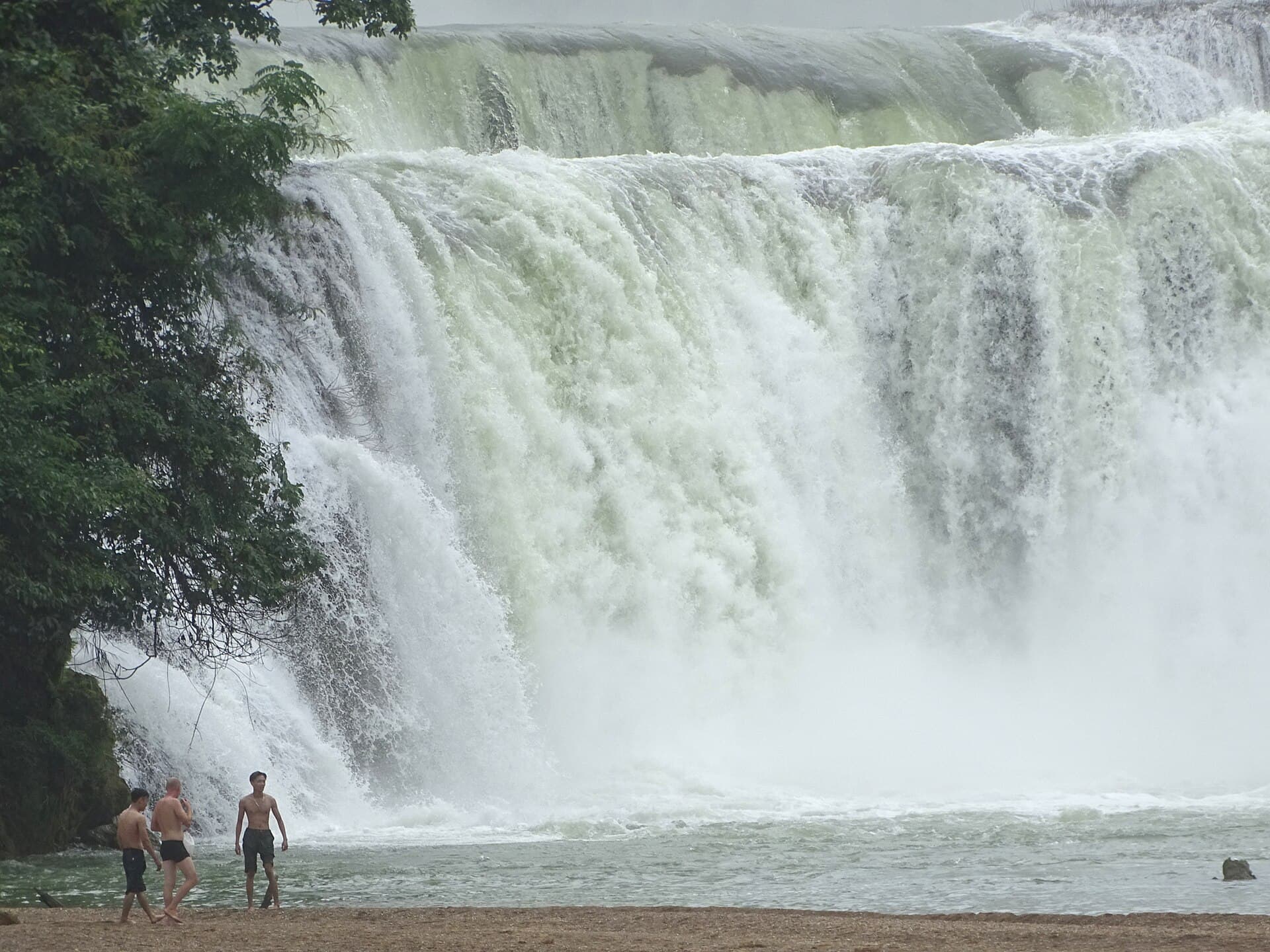
The Cao Bang loop is a three-to-four-day motorbike circuit through the Non Nuoc Cao Bang UNESCO Global Geopark in Vietnam's far northeast, ridden as two arms out of Cao Bang city: east to Ban Gioc waterfall, Nguom Ngao cave and the karst-and-paddy valleys of Phong Nam, and west to Pac Bo cave, where Ho Chi Minh based his revolution in 1941. Three days covers the core, four is the version most riders are happiest with, and planned sensibly no day needs much more than three to four hours in the saddle. It suits travellers who want the karst scenery and homestay nights of the far north without the convoy culture of the Ha Giang loop — the trade being gentler passes, thinner infrastructure and a bit more self-reliance. This guide covers the route, day splits, buses from Hanoi, bike rental, seasons, fuel, cash and food.
Cao Bang versus Ha Giang: the honest comparison
Cao Bang is routinely described as "Ha Giang ten years ago", and the cliche largely holds. Both provinces hold UNESCO Global Geopark status — Non Nuoc Cao Bang was listed in April 2018, Vietnam's second after Dong Van — so the geology is certified world-class in both. The difference is everything around the geology.
| Cao Bang loop | Ha Giang loop | |
|---|---|---|
| Crowds | Sparse; you can ride an hour without seeing another tourist | Heavy in peak season; convoys of easy-rider groups |
| Scene | Quiet homestays, family dinners | Party hostels, karaoke nights, organised tours |
| Headline sight | Ban Gioc waterfall | Ma Pi Leng Pass |
| Roads | Mostly good asphalt, gentler gradients | More extreme passes, more exposure |
| Infrastructure | A handful of rental shops, fewer mechanics, less English | Deep: dozens of operators, English everywhere |
| Logistics | More planning, more self-reliance | Turn up and book anything |
Nothing on the Cao Bang loop delivers the single vertiginous drama of Ma Pi Leng — the passes here are scenic rather than jaw-dropping, and the beauty is cumulative: river valleys, rice paddies pressed against karst walls, and a genuinely spectacular waterfall. English is thin outside the main homestays, restaurant options vanish between towns, and if your bike breaks down you may wait a while for help. If this is your first Vietnam loop and you want maximum drama with zero friction, Ha Giang remains the answer. If you have done Ha Giang, or the idea of a karaoke-hostel convoy makes you want to stay home, Cao Bang is the better trip. For where it sits among Vietnam's other quiet corners, see our off-the-beaten-path atlas.
The route: two arms from Cao Bang city
Unlike Ha Giang's single ring, the Cao Bang loop is really two arms sharing a hub — ride one, both, or extend either.
The eastern arm (the main event). From Cao Bang city, QL3 runs east over Ma Phuc Pass — the most photogenic stretch of tarmac on the loop — to the town of Quang Uyen, where DT206 branches north through Trung Khanh district to Ban Gioc waterfall, around 85 km all in. The asphalt is mostly in good condition; the hazards are the trucks serving the China border crossings, which overtake enthusiastically on hairpins, and rockfall debris after heavy rain. About 3 km from the falls sits Nguom Ngao cave, a long, well-lit river cave comfortably among the best in northern Vietnam, beside the Khuoi Ky stone-house village of Tay stilt houses. North of Trung Khanh town, the Phong Nam and Ngoc Con valleys are the loop's quiet masterpiece — the Quay Son river winding between limestone towers and rice paddies right along the Chinese border, best at golden hour. Many riders return a different way, dropping south from the falls on the DT206/DT207 border roads via Ha Lang back to Quang Uyen. The much-photographed Angel Eye mountain (Nui Thung) — a karst peak with a natural hole through its summit — sits off this eastern network and suits four-day itineraries.
Ban Gioc itself deserves its billing: tiered curtains of water on the Quay Son river, which forms the Vietnam–China border, with bamboo rafts running close to the spray. It is one of the largest waterfalls in Southeast Asia and among the biggest anywhere on a national border. We keep it short here because our dedicated Ban Gioc waterfall guide covers tickets, rafts, viewpoints and timing in full.
The western arm (history and highlands). Pac Bo cave lies roughly 50–60 km north of Cao Bang city in Ha Quang district, reached on quiet, good roads signposted off QL4A and the start of the Ho Chi Minh Road — the KM0 marker is here. This is where Ho Chi Minh lived and worked in 1941 after three decades abroad, beside the jade-green stream he named after Lenin. As a half-day ride it pairs a genuinely pretty valley with the north's most significant historical site. Riders with a fifth day continue southwest through the Phia Oac national park highlands toward Bao Lac — which is also the standard way to link Cao Bang onward to the Ha Giang loop and make one long northern super-loop.
How many days: 3, 4 or 5
| Version | Covers | Who it suits |
|---|---|---|
| 3 days | Eastern arm with a night near Ban Gioc, Nguom Ngao, plus Pac Bo as a half-day | Riders on a schedule; covers the headlines but rushes the valleys |
| 4 days | All of the above plus a slow day in Phong Nam and Ngoc Con and the Angel Eye detour | The sweet spot — the valleys are the point, not a bonus |
| 5 days | Adds the Phia Oac highlands and the run toward Bao Lac | Photographers, slow travellers, anyone linking onward to Ha Giang |
A sensible four-day split: day one east over Ma Phuc Pass to Ban Gioc and Nguom Ngao, sleeping near the falls; day two the Phong Nam and Ngoc Con valleys and Angel Eye, sleeping in a valley homestay or back in the city; day three the Pac Bo run; day four spare — weather buffer, the Ha Lang border road, or an early bus back. Distances are short by Ha Giang standards, which keeps the trip relaxed rather than an endurance event.
Getting there and getting a bike
Hanoi to Cao Bang is a bus journey of around 6–8 hours — there is no airport or rail line. Sleeper and limousine-cabin services run day and night; as of mid-2026 expect roughly 250,000–450,000 VND for a sleeper berth and somewhat more for private cabins. Operators on the route include Hiep Giang, Thanh Ly and Khanh Hoan, bookable via aggregators such as 12Go or Vexere — often slightly cheaper bought in person. A night bus puts you in Cao Bang city early enough to collect a bike and start riding the same morning.
Renting a bike is where Cao Bang's thinness shows. A handful of dedicated rental outfits and bike-renting homestays operate in Cao Bang city — nothing like Ha Giang's wall of shops — with semi-automatic bikes at around 100,000–180,000 VND per day as of mid-2026 and manuals somewhat more. Passport or deposit is standard. Because supply is small, reserve a few days ahead, particularly for autumn weekends. The legal position is the same as everywhere in Vietnam: you need a motorbike licence valid here, which for most foreigners means a 1968-Convention International Driving Permit — the full reality is in our motorbike rental guide.
Not riding yourself? Easy-rider and car-with-driver options exist but the local market is small; many guided Cao Bang loop motorbike tours actually depart from Hanoi or Ha Giang rather than Cao Bang city, so arrange before you arrive rather than counting on walk-up availability. A car with driver covers the same sights in comfort and suits families — you lose the open-air riding, not the scenery. Vietnam Coracle's northeast route notes are the best independent reference for going deeper than the standard circuit.
Fuel, cash and season
Withdraw everything you need in Cao Bang city — working ATMs are effectively absent once you leave, and homestays and rafts are cash businesses. Our Vietnam ATM guide covers which banks charge least. Fuel is easier: district towns like Quang Uyen and Trung Khanh have petrol stations, but top up before heading into the border valleys, where stations thin out.
On timing, the falls and the paddies run on different clocks that overlap in autumn. Ban Gioc carries maximum water during and just after the rains, roughly July to September; the rice in Phong Nam turns gold around late September and October; and the riding weather turns cool and dry from October. September to November is therefore the window — full falls, golden valleys, decent roads. The wet months bring downpours and rockfall debris on the passes. Winter, December to February, is genuinely cold up here — single-digit Celsius mornings are normal — and the falls shrink, so pack proper layers or pick another season.
Where to stay and what to eat
The pattern is simple: Cao Bang city as the staging base — hotels, hostels and homestays, plus your bike pickup and cash stop — then family homestays on the loop. These cluster near Ban Gioc, in the Khuoi Ky stone village by Nguom Ngao, and in the Phong Nam valley, typically around $10–20 per night with breakfast as of mid-2026, with set family dinners (rice, greens, pork or duck, and the local rice wine) a few dollars extra. Rooms are limited in number rather than quality, so book the Ban Gioc-area night ahead in peak autumn.
Cao Bang's food is a genuine reason to linger. The province's signature is banh cuon Cao Bang — steamed rice rolls served submerged in a hot pork-bone broth rather than with the usual dipping sauce, eaten for breakfast everywhere in the city. Vit quay bay vi, seven-flavour roast duck marinated with local mac mat leaves, is the celebratory dish; you will smell it before you see it. Ride in autumn and Trung Khanh adds Vietnam's most famous chestnuts, sold roasted by the roadside.
Limitations
- Distances and timings are planning estimates. The 85 km figure to Ban Gioc and the 50–60 km to Pac Bo vary with your exact route and detours.
- Prices shift. Bus fares, rental rates and homestay prices are hedged mid-2026 figures from operator listings and rider reports, not a live feed — confirm when booking.
- The rental market is small enough to sell out. A busy autumn weekend can exhaust Cao Bang city's bike supply in a way that never happens in Ha Giang; reserving ahead is a real requirement, not boilerplate.
- Border-area conditions can change. The eastern valleys hug the China border; carry your passport, and expect the occasional checkpoint or closed side road without notice.
- Ban Gioc detail is deliberately thin here. Tickets, raft prices, viewpoints and the China-side story live in our dedicated Ban Gioc guide.