
This is an independent atlas of Vietnam's off-the-beaten-path destinations in 2026 — the country's response to the volume saturation that has visibly hit Ha Long, Sapa, Hoi An, and Phu Quoc. It maps 18+ second-tier destinations across the north, central highlands, central coast, and Mekong delta that experienced travelers can use to stay ahead of the development curve.
The atlas exists because most English-language off-beat coverage stops at "go to Ha Giang" — a destination that received over 525,000 visitors in 2025 and is itself now subject to safety crackdowns and tour-volume increases. The real off-beat circuit in 2026 is one rung past Ha Giang and Sapa: Cao Bang + Ban Gioc, Pu Luong, Mai Chau, Ba Be, Bac Ha, Du Gia, Phu Yen, Quy Nhon, Mang Den, Kon Tum, Pleiku, Ninh Thuan, Con Dao, Ha Tien, Tra Vinh, Soc Trang, An Giang. Each of these has a sourced visitor-volume figure, a development-risk timeline, and an operational entry point (homestays + hotels + transport + permits + seasonality).
Every figure here traces to a named source — Vietnam News, VnExpress, VietnamPlus, the General Statistics Office, UNESCO Global Geopark inscriptions, provincial tourism portals, Vietnam Coracle long-form features, World Bank Vietnam blogs, and the Vietnamese government's Multi-Value Tourism Strategy to 2030 documentation.
The page is updated annually each May, post Q1 provincial arrival data. The 2026 figures are the baseline 2027 will measure against. Year-stamped slug — anchorable in time.
Quick summary — the volume-saturation context
| Destination | 2024-2025 visitor volume | Local population | Source |
|---|---|---|---|
| Hoi An | 4.43M visitors 2024 (vs 202,000 in 1999) | ~120,000 | VnExpress International; VnEconomy |
| Phu Quoc | 7.5M visitors in first 11mo 2025 | ~150,000 | Vietnam News |
| Khanh Hoa (Nha Trang) | 279k Russian + 1M Korean H1 2025 | ~1.2M | Vietnam+ |
| Ha Long Bay | Daily cap 38,000 (down from 45,000 pre-pandemic); 500+ overnight vessels peak season | — | VisitHalongBay |
| Ha Giang | 525,000+ visitors 2025, +safety regulation after April Wates incident | ~870,000 | Travel and Tour World; Vietnam Coracle |
| Cao Bang | 1.52M visitors H1 2025 (+47.7% YoY); intl arrivals +176.8% | ~530,000 | Vietnam News; VietnamPlus |
| Quy Nhon (Binh Dinh) | 9.2M visitors 2024 (+83.9% YoY) | ~1.5M | Nhan Dan; Vietnam News |
| Bai Xep (Phu Yen) | ~20,000/yr post-2025 merger | tiny | Legend Travel Group |
Why this atlas exists
Three gaps in existing English-language off-beat coverage:
-
Most "off-beat Vietnam" lists are stale. Articles published 2018-2022 still recommend Ha Giang, Sapa, and Phu Quoc as off-beat. By 2025-2026 these are core volume destinations. The actual current off-beat circuit has moved one tier further out.
-
The volume-saturation data is rarely cited. Foreign-language coverage rarely uses Vietnam General Statistics Office provincial data, Vietnam News reporting on annual arrivals, or the Multi-Value Tourism Strategy documents — leaving travelers unable to judge how off-beat a destination actually is.
-
The development-risk timeline is missing. Most off-beat coverage doesn't flag the expressway openings, airport modernizations, master-planned tourism zones, and cable-car projects that telegraph when an off-beat destination is about to absorb the volume curve. The atlas centres this timeline.
The audiences this atlas serves: foreign repeat visitors to Vietnam; slow-travel + adventure-tourism press; embassy advisory writers; academic researchers studying overtourism patterns in Southeast Asia; tour operators planning second-tier itineraries; and the Vietnamese government tourism diversification policy community.
Methodology
The atlas draws on six layers of sources, in this order of precedence:
| Layer | Source | How it's used |
|---|---|---|
| Provincial visitor data | Vietnam General Statistics Office; Vietnam News provincial reports; VietnamPlus | Annual arrivals + YoY growth |
| UNESCO recognition | UNESCO Global Geoparks; UNESCO Biosphere Reserves; UNESCO World Heritage | Inscriptions + boundaries |
| Multi-Value Tourism Strategy | Vietnam+ policy coverage 2025; Government decisions | National-strategy framing |
| Operator + accommodation primary | Mai Chau Ecolodge, Pu Luong Retreat, Avana Retreat, Anantara Quy Nhon Villas, Six Senses Con Dao, Amanoi, Stelia Beach Phu Yen direct websites | Operational entry points |
| Long-form regional features | Vietnam Coracle; Saigoneer; VnExpress Travel; Vietnam Discovery | Routes + nuance + ground-truth |
| Press + analysis 2024-2026 | SCMP; Travel and Tour World; Adventure.com; Nhan Dan; VnEconomy | Saturation + leakage signal |
Observation window: March-May 2026.
Hard rule: every figure cites a named source. Uncertain claims flagged "[unverified]".
Northern off-beat — the post-Sapa post-Ha Giang circuit
Ban Gioc Waterfall + Non Nuoc Cao Bang UNESCO Global Geopark
Non Nuoc Cao Bang UNESCO Global Geopark was inscribed April 12 2018, covers 3,683 km² across 36 communes, and contains geological evidence spanning over 500 million years. UNESCO revalidated it with a "Green Card" (highest rating) in its 2026 review (UNESCO IGGP page; VietnamPlus; Nhan Dan).
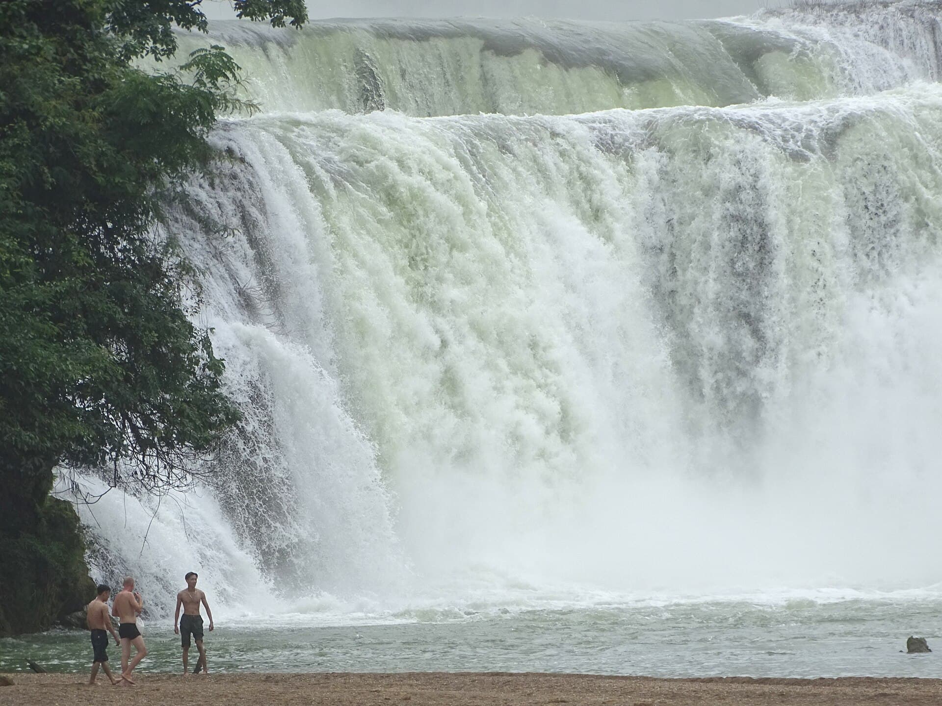
Ban Gioc Waterfall sits on the Quay Son River, marking the China-Vietnam border in Trung Khanh District. 30 m high and 300 m wide — Vietnam's widest waterfall, Southeast Asia's largest natural waterfall, and the fourth-largest cross-border waterfall in the world after Iguazú, Victoria, and Niagara (Vietnam Coracle; VOV World; Lily's Travel). The China-Vietnam Detian-Ban Gioc Cross-Border Tourism Cooperation Zone began official operation in October 2024, allowing limited reciprocal day visits in fixed tour groups (Manila Times / GlobeNewswire).
| Stat | Value |
|---|---|
| Inscribed | UNESCO Global Geopark April 12 2018 |
| Geopark area | 3,683 km² / 36 communes |
| Ban Gioc dimensions | 30 m high × 300 m wide |
| World rank (cross-border falls) | 4th |
| Cao Bang H1 2025 visitors | 1.52M (+47.7% YoY) |
| Cao Bang H1 2025 intl arrivals | +176.8% |
| Hanoi → Cao Bang travel | 6.5-9h sleeper bus / minivan; Dong Dang-Tra Linh expressway phase 1 target May 19 2026 |
Other Cao Bang sites:
- Nguom Ngao Cave: 2,769.6 m measured length; 945.8 m open to visitors; two entrances; coral-like calcite formations (VietnamPlus 2025)
- Pac Bo Historical Site: Ho Chi Minh re-entered Vietnam here February 1941 after 30 years abroad; 15 m² cave; Eighth Plenum of Indochinese Communist Party + Viet Minh founding; Special National Relic; entry 20,000 VND (~$1)
- Khuoi Ky Stone Village: 400+ years old, 14 Tay stone-built stilt houses over 10,000 m²; homestays with home-cooked meals
Best season: September-October (post-rainy water volume) or April-May (gentler turquoise pools).
Ba Be National Park
Vietnam's largest natural freshwater lake and its highest natural lake (~150 m elevation). Surface 3-5 km² seasonally; average depth 17-23 m, max 35 m; three connected basins (Pe Leng, Pe Lu, Pe Lam — "Ba Be" = "Three Lakes" in Tay). Park established 1992 covering 100.48 km² (ASEAN CHM; IZITour; Wikipedia).
Caves: Puong Cave (300 m × 30 m, on the Năng River), Hua Ma Cave (>700 m long, 40-50 m ceiling), Tham Phay Cave.
Villages: Tay-majority Pac Ngoi village has 40+ traditional stilt houses; homestays USD 5-24/night including home-cooked dinner.
Access: Hanoi → Ba Be ~6-7 hours; Cao Bang → Ba Be 4-5 hours.
Pu Luong Nature Reserve
17,662 hectares across Quan Hoa and Ba Thuoc districts, Thanh Hoa province; roughly two-thirds tropical forest with karst peaks and stepped rice terraces.
vs Sapa: less built-up, far fewer day-trippers, homestays remain family-run rather than corporatised.
| Property | Rate USD/night | Class |
|---|---|---|
| Pu Luong Retreat | from ~$89 | 4-star eco-lodge, 9 bungalows + 16-bed stilt house, infinity pool |
| Pu Luong Eco Garden | ~$60-150 | Mid-range |
| Local homestays | $15-40 | Family stilt house |
| Avana Retreat (Mai Chau side) | from ~$360 | 5-star, 36 villas |
Highlights: Hieu Waterfall (Hieu Village, swimmable pools); Pho Doan Market Thursdays + Sundays (Muong + Thai traders, opens ~7 AM).
Access: Hanoi → Pu Luong 185 km, 4-5 hours by shuttle bus / limousine van / private car; tickets ~$15-20. Best seasons: May-June (water-filled terraces) + September-October (golden harvest).
Mai Chau Valley
130-160 km west of Hanoi; population overwhelmingly White Thai with Black Thai, H'Mong, Dao, Muong, Tay, Hoa minorities. Lac Village (~700-year history) and Pom Coong Village are the two most-visited White Thai stilt-house homestay clusters.
Accommodation: Mai Chau Ecolodge from ~$80-125/night (54 ethnic-Thai-style stilt-house-design rooms); Avana Retreat from ~$360 (36 villas, 4 heated infinity pools); local White Thai homestays $8-25.
Cycling routes through rice paddies are more accessible than Sapa trekking.
Bac Ha Sunday Market
Lao Cai province, ~110 km from Sapa. Largest weekly ethnic-minority market in northwest Vietnam — Flower H'Mong, Phula, Dao Tuyen, Tay, Nung, Giay traders in full traditional dress.
Market-week schedule (rotating regional markets):
| Day | Market | Distance from Bac Ha |
|---|---|---|
| Tuesday | Coc Ly | ~35 km |
| Wednesday | Sin Cheng | ~40 km |
| Thursday | Ban Lien | ~20 km |
| Friday | Lung Phinh | ~15 km |
| Saturday | Can Cau | ~25 km |
| Sunday | Bac Ha | town center |
Best browsing: 6-9 AM. Tour pricing: 1-day from Sapa $40-80; 2D1N market+homestay $90-180.
Du Gia + Yen Minh + Lung Cu (Ha Giang sub-circuits)
After the British teenager Orla Wates died on the Ha Giang Loop in April 2026, the provincial Department of Culture, Sports and Tourism issued April 13 directives tightening tour rules: legally-binding contracts, banned unlicensed operators, banned mid-itinerary changes, mandatory accident reporting (VnExpress; DTiNews).
Side-trips for repeat Ha Giang visitors:
- Du Gia (Yen Minh district, ~70 km from Ha Giang City): Tay ethnic village + eponymous waterfall (clear turquoise pool, ~2 km from village, swimming + cliff jumping); dozens of family homestays in wooden stilt houses
- Lung Cu Flag Tower: Vietnam's northernmost monument on Lung Cu (Dragon Mountain), Dong Van District. Summit elevation ~1,400-1,470 m; tower 33.15 m tall (octagonal, inspired by Hanoi's flag tower); flag 54 m² to symbolise Vietnam's 54 ethnic groups; Chinese border lies ~3 km further north
- Sung La Valley + Pho Cao: Sung La sits 130 km from Ha Giang City; H'Mong ~85% of village population; Lung Cam hamlet inside Sung La is the filming village of The Story of Pao and a buckwheat-flower hotspot in autumn
Northeast Circuit (Cao Bang + Ban Gioc + Ba Be + Ha Giang combo)
Vietnam Coracle documents three scenic routes linking Ha Giang ↔ Ba Be Lake ↔ Cao Bang and five motorbike loops across Cao Bang, Lang Son and Bac Kan.
| Style | 7-day cost (USD) |
|---|---|
| DIY motorbike + budget homestays | ~$200-400 |
| Easy Riders (with guide-rider) | from ~$560 (7D/6N) |
| Private car + driver, mid-range | ~$800-1,500 |
Difficulty: sharp bends, steep passes, occasional gravel and landslide debris on Ha Giang-Cao Bang interconnect; 2026 safety crackdown emphasises licensed operators only.
Lesser-known northern destinations briefly
- Quan Ba "Heaven's Gate": ~1,500 m viewpoint on Quan Ba Pass (Ha Giang), 43 km north of Ha Giang City; gateway to Twin Mountains ("Nui Doi" / "Fairy Bosom")
- Hoang Su Phi (Ha Giang western edge): rice terraces across 5-6 communes; National Monument designated 2012 for 5 communes' rice terraces; best Sept-Oct golden harvest
- Mu Cang Chai (Yen Bai): ~2,200 ha rice terraces; 500 ha across La Pan Tan + Che Cu Nha + De Xu Phinh designated National Heritage 2007; altitudes 1,000-2,000 m; cultivated by H'Mong
- Tam Dao (Vinh Phuc, ~80 km NW of Hanoi): hill station at 900-1,000 m, French-built 1904 colonial summer retreat
- Ba Vi National Park (~50 km west of Hanoi): three peaks (Dinh Vua 1,296 m, Tan Vien 1,226 m, Ngoc Hoa 1,120 m); French built ~200 villas during colonial period (ruins now)
- Cuc Phuong National Park (Ninh Binh): Vietnam's first national park, founded 1962; 22,000 ha; Endangered Primate Rescue Centre (Frankfurt Zoological Society project since 1993, now with Zoo Leipzig; 180+ offspring across 9 species)
- Mau Son Mountain (Lang Son, 180 km NE of Hanoi): twin peaks Phia Po 1,541 m + Phia Me 1,520 m; 7,000+ billion VND eco-tourism + cable-car complex in active construction (Sapa-pattern overtourism risk)
Central + southern off-beat — the post-Hoi An post-Phu Quoc circuit
Phu Yen province (the emerging coast star)
Administrative note: Vietnam's 2025 restructuring merged Phu Yen into Dak Lak Province; Phu Yen and Tuy Hoa are now wards under the consolidated administration. Destination identity remains intact for tourism marketing.
| Site | Location | Key fact |
|---|---|---|
| Bai Xep beach | ~15 km from Tuy Hoa | Filming location for Yellow Flowers on the Green Grass (Victor Vũ, 2015) — Vietnam's submission for Best Foreign Language Film at the 89th Academy Awards |
| Da Dia Reef | ~35 km north of Tuy Hoa | Tens of thousands of hexagonal/pentagonal basalt columns; National Relic since 1997; basalt formed ~200M years ago from Van Hoa Plateau volcanism |
| Mui Dien / Cape Varella | Hoa Tam Commune | Easternmost point of mainland Vietnam; lighthouse built by French 1890 (26.5 m tall, 110 m above sea level); one of 8 Vietnamese lighthouses over 100 years old; National Landscape Monument 2008 |
| Vung Ro Bay | Hoa Xuan Nam Commune | Strategic port of Ho Chi Minh Trail at Sea 1961-1975; received 4 supply ships Nov 1964-Feb 1965; National Special Relic 2021 |
Geopark status: Phu Yen Geopark seeking UNESCO Global Geopark designation — not yet inscribed. Vietnam currently has only two UNESCO Global Geoparks: Dong Van Karst (Ha Giang, 2010) and Non Nuoc Cao Bang (2018).
Accommodation anchor: Stelia Beach Resort (Doc Lap Street, central Tuy Hoa) — 5-star, 52 rooms/villas, Mediterranean/Santorini-style design; ranked #1 of 28 hotels in Tuy Hoa on TripAdvisor. Guesthouses $20-80.
Access: Tuy Hoa airport (TBB) — domestic only — daily flights from HCMC (Vietnam Airlines, VietJet, Jetstar) + Hanoi (VietJet).
Quy Nhon (Binh Dinh province)
The surge is real and documented:
| Stat | Value |
|---|---|
| 2024 visitors | 9.2M (+83.9% YoY) |
| 2024 international | ~93,850 |
| 2024 domestic | 9.1M |
| 2024 revenue | VND 25.5 trillion (~$1.02B, +55.4% YoY) |
| Q1 2025 visitors | 4.2M in first 4 months alone |
| 2025 target | 10M arrivals |
| Site | Notes |
|---|---|
| Eo Gio | 397,000 visitors 2024; "one of Vietnam's most stunning sunset spots" |
| Ky Co beach | 270,000 visitors 2024; nicknamed "Maldives of Quy Nhon" |
| Banh It Towers | 4-tower complex, late 11th-early 12th c.; National architectural relic 1982 |
| Thap Doi (Twin Towers) | 2 km from city center; late 12th-early 13th c.; red brick |
| Duong Long Towers | Tallest remaining Cham tower in Vietnam (central ~40 m) |
| Hon Kho Island | Ferry from Nhon Hai fishing village (~16 km from Quy Nhon); 10-min boat; round-trip ~VND 100,000/person |
| Quang Trung Museum (Tay Son) | 45 km NW of Quy Nhon; inaugurated December 24 1977; 18 ha, 9 rooms, 11,000+ artifacts honoring Emperor Quang Trung / Tay Son brothers |
Cham concentration: Binh Dinh has 14 preserved Cham towers from the 11th-15th centuries — the largest in Vietnam, more than My Son in Quang Nam.
Cuisine: bun cha ca Quy Nhon (fish-cake noodle soup, barracuda/mackerel broth); nem nuong (grilled pork sausage).
Luxury anchor: Anantara Quy Nhon Villas — 25 luxury pool villas on 7 acres fronting a private cove, mountains on three sides overlooking Quy Nhon Bay.
Access: Phu Cat airport (UIH) 35 km from Quy Nhon. $120M terminal modernization completed 2024; secondary 3,200 m runway target June 2026; new international routes to Bangkok, KL, Singapore pending (Thai AirAsia, AirAsia X, Malaysia Airlines interest).
Central Highlands ethnic-minority destinations (beyond Da Lat)
| Destination | Province | Key feature |
|---|---|---|
| Buon Ma Thuot | Dak Lak | Coffee capital (covered in Coffee Atlas) |
| Kon Tum (city) | Kon Tum | Wooden Church 1913-18 (Anthoshorea roxburghii wood), Roman + Bahnar fusion architecture; stilt structure on wooden pillars |
| Kon Klor Rong House | Kon Tum | Communal Bahnar stilt house — meetings, rituals, festivals |
| Mang Den | Kon Tum (Kon Plong district) | "Second Da Lat"; ~60 km NE of Kon Tum city, altitude 1,200 m, year-round temps 16-20°C; pine plantation legacy from French colonial era |
| Bien Ho / T'Nung Lake | Gia Lai (Pleiku) | Volcanic crater lake; 280 ha surface, depth 16-19 m avg / 40 m max; 800 m elevation; ~7 km NW of Pleiku city |
| Yok Don NP | Dak Lak | 115,545 ha; Vietnam's first ethical elephant tourism site (Animals Asia partnership Oct 2018 — ended riding) |
Mang Den development risk: Government has formally planned expanding to 90,000+ hectares structured as "two development corridors, three tourism centres, four urban areas" with resort/eco/cultural/historical tourism components. Off-beat window ~3-5 years.
Yok Don's ethical elephant model: Since October 2018, four elephants (1 male, 3 female) "roam freely under the supervision of their mahouts" — no riding. Ede minority homestay/cooking experiences in Jang Lanh village.
South-central coast: Ninh Thuan + Khanh Hoa hinterland
| Site | Province | Key fact |
|---|---|---|
| Po Klong Garai Cham temples | Ninh Thuan | ~7 km from Phan Rang-Thap Cham; 3 terracotta towers (main 20.5 m, fire 9.31 m, gate 8.56 m); dated 13th c. |
| Vinh Hy Bay | Ninh Thuan | ~38 km from Phan Rang; one of Vietnam's 4 most beautiful bays; coastal road through Nui Chua National Park |
| Amanoi | Ninh Thuan, Vinh Hy Bay | Aman flagship Vietnam; mountainous promontory of Nui Chua National Park overlooking Vinh Hy Bay |
| Ba Moi Vineyard | Ninh Thuan | Vietnam's largest grape-producing province; ~20 wine estates; 7 km from Phan Rang city |
| Doc Let Beach | Khanh Hoa (Ninh Hai ward, Ninh Hoa town) | ~50 km from Nha Trang; 6 km shoreline; shallow swimming water |
| Whale Island / Hon Ong | Khanh Hoa, Van Phong Bay | French-owned resort est. 1997; only accommodation on the 100 ha island; 32 bungalows; from ~$86/night |
| Hon Mun MPA | Khanh Hoa | Vietnam's first marine protected area (1998); ~160 km²; 350+ hard coral species, 1,500+ marine species |
Cu Lao Cham Islands (Hoi An offshore — borderline off-beat)
- UNESCO recognition: Cu Lao Cham-Hoi An World Biosphere Reserve, designated May 26 2009
- Geography: 8 islands ~15 km off Cua Dai Beach; high-speed canoes from Cua Dai port, 15-20 min transit
- Visitor cap: Authorities limited to 3,000/day to counteract overtourism (2024 onwards); 2019 received ~440,000 visitors (avg ~1,200/day, peak days >3,000)
- Fees: Entrance VND 70,000/person + environmental fee VND 20,000/person
Editorial note: Borderline "off-beat" — the daily cap helps preserve it but the 1-day boat-trip model is already mass-tourism style. Overnight homestays inside the island village are the genuine slow-travel option.
Ha Tien + southern Mekong alternatives to Phu Quoc
| Site | Province | Key fact |
|---|---|---|
| Ha Tien (town) | Kien Giang | On Gulf of Thailand; 8 km from Cambodia border; "Ten Sights" cluster |
| Thach Dong Cave | Ha Tien (My Duc commune) | Limestone tower ~45 m diameter at base, ~93 m high |
| Mui Nai Beach | Ha Tien | "Deer's Nose" promontory; views to Hai Tac (Pirates) Islands ~11 km offshore |
| Hon Phu Tu (Father-Son Rocks) | Kien Giang | "Phu" (Father) rock collapsed into the sea in 2006; only "Tu" (Son) remains |
| U Minh Thuong NP | Kien Giang | Established 2002; ~8,038 ha; one of two remaining major peat swamp forests in Vietnam |
| U Minh Ha NP | Ca Mau | 82.86 km²; established January 20 2006; core zone of Ca Mau UNESCO Biosphere Reserve; 79 plant families, 32 mammals, 74 birds |
Mekong Delta beyond Can Tho
Soc Trang Khmer pagodas:
- Bat Pagoda (Chua Doi): 452-year-old Khmer temple (construction begun 1569); named for resident bat colony; National Architectural Art Relic since 1999
- Clay Pagoda (Chua Dat Set / Buu Son Tu): 200+ years old; hand-sculpted clay statues by monk Ngo Kim Tong (work from age 20 until death at 62)
- Soc Trang has 200+ pagodas, 92 Khmer Theravada
Tra Vinh: 140 Khmer temples; ~31% of Tra Vinh's population is ethnic Khmer Krom. Notable: Hang Pagoda, Ao Ba Om square man-made lake.
An Giang: Sam Mountain near Chau Doc (Vietnam-Cambodia border); Tra Su Melaleuca Forest — 845 ha across 3 districts (Tinh Bien + Chau Phu); 140+ plant species, ~80 freshwater fish species, rare birdlife; best Sept-Nov flood season when duckweed forms green carpet. Cham Muslim community (Chau Giang/Chau Doc) — Mubarak Mosque, Cham Museum, traditional stilt houses.
Tram Chim NP (Dong Thap): ~7,300 ha; 230+ bird species including Sarus Crane. Critical decline: 1990s had 1,000+ Sarus Cranes; only 4 spotted in 2024 (climate change + reduced floodwaters). Sa Dec Flower Village ~60 km away — the Mekong's largest flower-growing area.
Con Dao Islands (the under-promoted luxury island)
Access: VASCO 45-min flights to Con Dao Airport (VCS) from HCMC. All flights restricted to daytime 6 AM-5 PM due to airport limitations. Ferry from Vung Tau is the budget alternative.
Prison history:
- Established February 1 1862 by Governor Bonard of Cochinchina
- 113-year operation 1862-1975; ~20,000 prisoners total
- Complex grew to 127 cells, 42 solitary rooms, 504 "tiger cages" (introduced 1940 — 1.45 m × 2.5 m concrete cells holding up to 12 shackled prisoners)
- Closed at noon April 30 1975; National Relic 1979, Special National Relic 2012
- "Almost all senior communist leaders apart from Ho Chi Minh spent time in French colonial prisons, most on Con Son" (The Diplomat)
Luxury anchor: Six Senses Con Dao — only 5-star beach resort on the island; 12 hectares along Dat Doc Beach; bamboo beachfront villas.
Bay Canh Island turtle conservation:
- Most important sea turtle nesting site in Con Dao
- Majority are green sea turtles
- Con Dao NP established 1993; ~400 green and olive ridley turtles nest annually at 14 sites May-October (peak Jun-Sep)
- 21,000+ nests assisted since 1995, >80% hatching rate, ~1.5 million baby turtles released
- New visitor regulations 2024-2025 limit turtle-watching impact
UNESCO caveat: Con Dao National Park was assessed in 2006 as "eligible to be a natural-cultural mixture World Heritage" — government is preparing the dossier. NOT a formally inscribed UNESCO Biosphere Reserve as of late 2025.
2024-2026 development-risk timeline
| Destination | Risk window | Trigger |
|---|---|---|
| Cao Bang + Ban Gioc | ~2-3 years | Dong Dang-Tra Linh expressway phase 1 May 2026 + 47.7% H1 2025 visitor growth |
| Mang Den | ~3-5 years | 90,000+ ha "national tourism zone" in planning |
| Quy Nhon | ~2-4 years | Phu Cat airport $120M done 2024 + new intl routes mid-2026 + 10M visitor target |
| Mau Son Mountain | ~3-5 years | VND 7,000+ billion eco-tourism + cable-car complex in active construction (Sapa-pattern) |
| Cu Lao Cham | Already arriving | 3,000/day visitor cap imposed |
| Con Dao | ~5+ years | Six Senses + government plans for additional 5-star anchors; turtle tour limits emerging |
| Pu Luong | ~5-7 years | Still small-scale; some boutique 5-star arrivals (Avana Retreat 2024) |
| Bac Ha + Hoang Su Phi + Du Gia | ~3-7 years | Still small-scale |
| Phu Yen | ~3-5 years | Geopark UNESCO inscription candidacy will accelerate if granted |
Practical logistics
Seasonality matrix
| Destination | Optimal months | Avoid |
|---|---|---|
| Ban Gioc / Cao Bang | Sep-Oct (post-rain water); Apr-May (turquoise) | Jun-Aug heavy rain landslides |
| Ba Be NP | Mar-Nov | Dec-Feb cold |
| Pu Luong | May-Jun (water-filled terraces); Sep-Oct (golden) | Nov-Apr dry/quiet |
| Mai Chau | Oct-Mar dry; Sep (harvest) | May-Sep heavy rain |
| Bac Ha | Year-round Sundays; spring plum blossom | — |
| Hoang Su Phi / Mu Cang Chai | Sep-Nov golden harvest | Apr-Aug wet |
| Lung Cu / Dong Van | Oct-Apr clear views, cool | May-Sep monsoon |
| Cuc Phuong | Apr-May butterfly migration | — |
| Phu Yen | Feb-Aug calm sea | Sep-Dec storms |
| Quy Nhon | Mar-Sep | Oct-Dec rainy |
| Central Highlands (Kon Tum, Pleiku, Mang Den, BMT) | Nov-Apr dry | May-Oct wet |
| Ninh Thuan / Phan Rang | Year-round (driest province in VN) | Oct-Nov storm tail |
| Cu Lao Cham | Mar-Aug boats run | Sep-Feb often suspended |
| Con Dao | Mar-Sep beach; turtle nesting May-Oct (peak Jun-Sep) | Oct-Feb rough seas |
| Mekong Delta (Tra Su flood) | Sep-Nov | — |
| Ha Tien | Nov-May | Jun-Oct monsoon |
Air access table
| Airport | Code | Notes |
|---|---|---|
| Tuy Hoa | TBB | Domestic only; daily HCMC + Hanoi flights |
| Phu Cat (Quy Nhon) | UIH | $120M terminal 2024; new international routes mid-2026 |
| Pleiku | PXU | Vietnam Airlines + VietJet domestic |
| Buon Ma Thuot | BMV | ~1 hr from HCMC |
| Con Dao | VCS | VASCO 45-min flights HCMC/Hanoi; daytime-only 6am-5pm |
| Cam Ranh (Nha Trang) | CXR | 32 weekly Russia flights + 17 daily Korea flights — international-heavy |
14-day "second-time Vietnam" route (northern-focus)
| Day | Location |
|---|---|
| 1 | Arrive Hanoi |
| 2-4 | Pu Luong (3 nights — homestays + Hieu Waterfall + Pho Doan market) |
| 5 | Mai Chau |
| 6-7 | Cao Bang + Ban Gioc (2 nights — waterfall + Nguom Ngao Cave + Pac Bo) |
| 8 | Ba Be NP (homestay Pac Ngoi village) |
| 9 | Return Hanoi |
| 10 | Fly Hanoi → Quy Nhon |
| 11 | Quy Nhon (Eo Gio + Ky Co + Cham towers) |
| 12 | Drive Phu Yen (Bai Xep + Da Dia Reef + Mui Dien) |
| 13 | Fly Tuy Hoa → HCMC; Mang Den or Con Dao add-on if available |
| 14 | HCMC departure |
Limitations
- Pricing is May-June 2026 USD at ~26,361 VND/USD; operator pricing fluctuates 5-15% seasonally.
- Visitor-volume figures are from provincial tourism bureau reports + Vietnam News + VietnamPlus; some are partial-year aggregates noted as such.
- Ban Gioc dimensions vary across sources (30 m × 300 m most cited vs 70 m × 208 m outliers); we use the conservative measurement.
- Phu Yen Geopark UNESCO status is candidate, not inscribed as of late 2025.
- Con Dao UNESCO Biosphere status is candidate (dossier in preparation), not inscribed.
- Phu Quoc "Tran Chau Cave" referenced in some sources is not surfaced as a major site in primary verification.
- Best-season month boundaries are typical ranges synthesised from operator pages, not government meteorological data.
- Tour package prices in USD ranges are aggregated from operator listings; verify with named operators for editorial publication.
- Tay/Bahnar/Hmong/Dao homestay descriptions are based on common operator practice; individual homestays vary.
- Development-risk timelines are projections based on visible pipeline; specific opening dates can slip.
Annual update commitment
| Date | Changes |
|---|---|
| 2026-07-24 | Initial publication. Pricing current to May-June 2026; visitor-volume data from H1 2025 provincial reports + 2024 full-year aggregates; Multi-Value Tourism Strategy to 2030 cited; Dong Dang-Tra Linh expressway phase 1 target May 2026; April 2026 Ha Giang safety crackdown noted. Next refresh May 2027. |
How to cite this
Nguyen, J. (2026). Vietnam Off-the-Beaten-Path Destinations Atlas 2026: Where to Go When You've Already Done the Volume Circuit. Day Trips Vietnam. Retrieved from https://daytripsvietnam.com/guides/vietnam-off-the-beaten-path-atlas-2026/
Published under Creative Commons BY 4.0. Editorial enquiries: info@daytripsvietnam.com.
Related research and reference
- Ha Long Bay Overtourism Research 2025 — Hoa Binh University 2025 study; volume-saturation data
- Hoi An Food Tourism Transformation — Hoi An visitor-volume + cultural transformation
- Hoi An Community-Based Tourism Sustainability — CBT model + sustainability
- Central Highlands Sustainable Tourism Research — Kon Tum + Mang Den + Buon Ma Thuot framework
- Vietnam Adventure & Outdoor Atlas 2026 — Northeast Circuit motorbike routes + Ha Giang safety
- Vietnam UNESCO Sites Atlas 2026 — Geopark + Biosphere context
- Vietnam Travel Cost Index 2026 — per-city cost baseline
- Vietnam Cost vs Southeast Asia 2026 — regional comparison
- Cost of 2-Week Vietnam Trip 2026 — full-trip budget framework