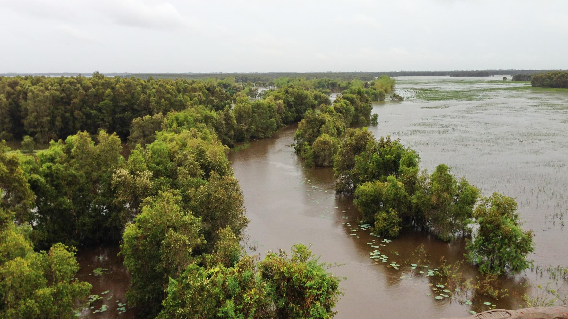
The Mekong Delta has two seasons. From December to April it is dry and sunny, with highs of 30-34°C and reliable boats and roads, the easiest time to travel. From May to November it is the rainy season, peaking in September, when heavy afternoon downpours are common. Two things overlap with the rains: the fruit season, with orchards at their fullest from about June to August, and the flood season, from about August to November, when the upper delta around Chau Doc and Dong Thap fills with water, peaking in October.
The Mekong Delta is flat, low and hot all year, so its weather is about rain and water, not temperature. Since the 2025 reforms, its provinces have been merged into larger units: Can Tho now includes Soc Trang and Hau Giang, An Giang includes Kien Giang, Dong Thap includes Tien Giang, and Vinh Long includes Ben Tre and Tra Vinh.
Mekong Delta weather at a glance
The table gives official long-run averages for Can Tho, in the heart of the delta, from the Vietnam Institute for Building Science and Technology, as published in Wikipedia's climate table.
| Month | High | Low | Rain | Rain days | Sunshine (h/month) |
|---|---|---|---|---|---|
| January | 30.2°C | 22.3°C | 10 mm | 2 | 245 |
| February | 31.2°C | 22.7°C | 4 mm | 1 | 243 |
| March | 32.7°C | 23.9°C | 15 mm | 2 | 281 |
| April | 33.9°C | 25°C | 42 mm | 6 | 259 |
| May | 33.2°C | 25.2°C | 223 mm | 16 | 210 |
| June | 32°C | 24.6°C | 310 mm | 20 | 176 |
| July | 31.4°C | 24.3°C | 336 mm | 22 | 183 |
| August | 31.2°C | 24.4°C | 338 mm | 22 | 180 |
| September | 31.1°C | 24.4°C | 451 mm | 22 | 166 |
| October | 31°C | 24.4°C | 301 mm | 22 | 178 |
| November | 30.7°C | 24.3°C | 137 mm | 14 | 193 |
| December | 29.7°C | 23°C | 42 mm | 7 | 215 |
The year totals about 2,200 mm of rain, roughly 95% of it from May to November. Temperatures barely move: the warmest month is only about 4°C warmer than the coolest by day. The pattern is the same as in Ho Chi Minh City, a few hours north-east, but wetter.
Dry season, December to April: the easiest time
This is the most comfortable time for the delta. Rain falls to 4 to 42 mm a month, the sun shines for 215 to 280 hours a month, and boats, buses and roads run smoothly. December to February are the most pleasant months, with highs around 30-31°C and nights around 22-23°C. The heat builds through March to about 34°C in April, the hottest month.
The season has its own highlights. Around Tet, the flower village at Sa Dec in Dong Thap fills with potted flowers for the holiday: its second flower festival, from 27 December 2025 to 4 January 2026, drew about 1.17 million visitors. The dry season is also when salt water pushes up the rivers as their flow falls, from about February to April; in late February 2026, it had reached 16 to 42 km inland on the main river mouths. It is a serious problem for farmers and water supplies, but it rarely affects visitors.
Rainy season, May to November: afternoon downpours
The rains arrive in May, rising to about 310-340 mm a month from June to August and a peak of about 450 mm over 22 days in September, then ease through October and November. Most rain comes as heavy afternoon downpours, with sunny or hazy mornings, so the dawn floating markets and morning boat trips usually go ahead. Temperatures stay at 31-33°C by day.
Fruit season coincides with the early rains. The orchards are at their fullest from about June to August, when durian, rambutan and mangosteen are harvested, according to VnExpress, and some Can Tho orchards from May.
The flood season, August to November
Every year, the Mekong rises with the monsoon rains upstream in Cambodia and Laos and spills across the upper delta. The flood season, known as mua nuoc noi, runs from about August to November, according to Vietnam's tourism ministry, peaking in October. It is concentrated in the upper delta: around Chau Doc and Tan Chau in An Giang, and the Thap Muoi plain and border villages of Dong Thap. Flood-season trips also run from places such as Tan Loc islet in Can Tho.
The water rises gradually, and the season is part of life rather than a disaster in most years. Locals fish with nets and traps, harvest water lilies and run canoe trips through flooded fields, and farmstays around Tram Chim in Dong Thap offer boat trips through lotus and water hyacinth. It is also the best time for the Tra Su melaleuca forest near Chau Doc, when the canals are high and carpeted with green duckweed; our Chau Doc guide covers it.
How high the water rises varies from year to year. For 2026, Vietnam's forecasters expected the upstream peak in the first half of October and the peak in Dong Thap to be about equal to 2025 or 0.1 to 0.2 m lower, as Tuoi Tre reported, so do not expect dramatic scenes every year.
Floating markets in every season
The Cai Rang floating market near Can Tho trades every day of the year, apart from the first two days of Tet and the Doan Ngo festival, and is busiest from about 5:00 to 6:30. The rainy season does not stop it. Our floating markets guide explains which markets still trade and how to hire a boat.
Typhoons: rare
In southern Vietnam, typhoons generally come between mid-October and late December, peaking in early November, and most weaken before reaching the delta. There are exceptions: Tropical Storm Linda struck Ca Mau in November 1997, the worst storm in southern Vietnam in at least a century, and Typhoon Durian crossed the delta in December 2006. For most trips, the rainy season is the only real weather concern.
What the weather means for your trip
Choosing the month. December to April for easy travel; June to August for fruit; September to November for the flood season and Tra Su; any month for Cai Rang at dawn.
Planning. Travel independently with our Mekong Delta without a tour guide, and rank the options with our day trips from Can Tho guide. Can Tho is about three hours from Ho Chi Minh City by expressway; see our Ho Chi Minh City to Can Tho guide.
Limitations
The table uses official long-run averages for Can Tho as reproduced on Wikipedia; the source does not state the averaging period or rain-day threshold, and the upper and lower delta differ. Flood levels vary a lot from year to year, and sources give slightly different flood-season months. Fruit seasons shift with each year's weather.
Workaround: use this page to choose the season, check the flood forecast if you are travelling for the flood season, and plan boat trips for the early morning in any month.